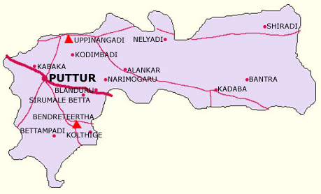
INTRODUCTION OF PUTTUR

Puttur is a town in the Dakshina Kannada district, in the Indian state of Karnataka. It is the headquarters of the Puttur Taluk. The town is located 52 km from Manglore, along the Mysore-Manglore highway, in a hilly region between the coast and the Weatern Ghars. In 2006, it has a population of 48,063. The major occupation of its inhabitants is agriculture. The National Research Centre for Cashew is located in Puttur, as well as the Campco Chocolate Factory.
Puttur is the second biggest town in the District, situated on Mangalore-Mysore Highway and is 52 km away from Manglore, the District head quarter. Puttur was the Taluk. Head Quarters to the present Sullia Taluk, Belthangady Taluk and present Vittla Head Quarters of Bantwal Taluk. After the taluk reorganization Puttur is the taluk head quarters with 37 Village Panchayaths covering 68 villages. Even after the reorganization of Taluks, Puttur continues to be a center for the economical, educational & medical services for the surrounding Taluks. The Southern portion of this Taluk is surrounded by the villages of Kerala State.
Geography
Puttur is located at 12.770 N 75.220 E[1]. It has an average elevation of 87 meters(285 feet).
The town muncipal area comprises portions of surrounding villages namely Balnad, Padnoor, Kabaka, Bannur, Chikkamudnoor, Kemminje, Aryapu villages in addition to the thickly populated Puttur Kasaba, the original Town area.
Agriculture
Puttur is an agro based town of the Coastal region surrounded by several hillocks with lush green forest situated in the belt of Western ghat heavy rainfall. The Major occupation of the people is agriculture. The crops grown mainly are paddy, areca, coconut, cashew, rubber, cocoa, chilli, vanilla, pepper and plantains. In addition dairy farming, sericulture and horticulture activities supplement the earnings of the people to some extent.
List of colleges

|
|
|
|
|
|
|
|